Sidera is a graphical user interface (GUI) written in MATLAB designed to provide visibility information of the Global Positioning System constellation satellites at a specific Earth location and time.
This software is a perfect tool for those interested in predicting when GPS satellites will be visible (above the horizon) at their antenna location.
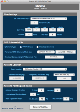
Sidera provides a very simple GUI that a user can manipulate to compute data regarding the visibility of the GPS constellation. GPS constellation data is precisely computed using the GPS ephemeris files and YUMA almanacs that are downloaded automatically as needed. Output data is provided in tabular format for easy external usage after GPS Visibility has completed.
Informative plots are provided that show the status of satellite visibility. These generated plots include:
-
✦ The number of satellites visible at the specified location and time
-
✦ The Azimuth-Elevation plots of each visible satellite
-
✦ Elevation of visible satellite with respect to antenna orientation and masking
-
✦ Geometric dilution of precision of navigation solution using visible satellites
In addition to specifying their location and time of observation, users also have the ability to input the pointing direction of the receiving antenna.